Trail On foot Oberhofen am Thunersee - Oberi Allmit - Bloch - Fixme - Photo

Tous les sentiers balisés d’Europe PRO

© OpenStreetMap contributors
Length
Length
3.7 km
Max alt
Max alt
946 m
Uphill gradient
Uphill gradient
130 m
Km-Effort
Km-Effort  
5.9 km
Min alt
Min alt
710 m
Downhill gradient
Downhill gradient
253 m
Boucle
Boucle
No
Signpost
Signpost
Creation date :
2022-02-14 09:03:56.749
Updated on :
2022-02-14 09:03:56.749

(0 Reviews)

On foot
On foot
1h19
Difficulty : Easy

Scan this QR Code to open this trail in the SityTrail application

FREE GPS app for hiking

Logo SityTrail SityTrail

IGN / Geographical institutes

Download SityTrail from the App Store Download SityTrail from Google Play

Logo SityTrail SityTrail World

The world is yours!

Download SityTrail from the App Store Download SityTrail from Google Play Download SityTrail on Huawei AppGallery

About

Trail On foot of 3.7 km to be discovered at Bern, Thun administrative district, Oberhofen am Thunersee. This trail is proposed by SityTrail - itinéraires balisés pédestres.

Description

Symbol: gelber Diamant

Positioning

Country:
Switzerland
Region :
Bern
Department/Province :
Thun administrative district
Municipality :
Oberhofen am Thunersee
Location:
Unknown
Start:(UTM)
398941 ; 5176989 (32T) N.

Trails nearby

Trail On foot Thun - Thun - Merligen - Photo
On foot
PRO

On foot

Easy
Thun, Bern, Thun administrative district, Switzerland
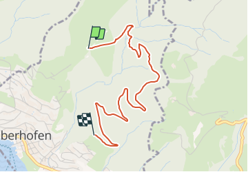
13.4 km | 18.8 km-effort
4h 17min
No
Trail On foot Spiez - Strandweg Thun - Photo
On foot
PRO

On foot

Easy
Spiez, Bern, Frutigen-Niedersimmental administrative district, Switzerland
5.6 km | 6 km-effort
1h 21min
No
Trail Walking Sigriswil - Gunten-Merligen - Photo
Walking
chbolzli

Walking

Medium
Sigriswil, Bern, Thun administrative district, Switzerland
6.8 km | 11.5 km-effort
2h 28min
No
Trail Other activity Steffisburg - descente de l'Aar en bateau     pneumatique - Photo
Other activity
chbolzli

Other activity

Easy
Steffisburg, Bern, Thun administrative district, Switzerland
23 km | 25 km-effort
2h 47min
No
Trail Walking Thun - hike26 - Photo
Walking
GUIDE+

Walking

Very easy
Thun, Bern, Thun administrative district, Switzerland
19.9 km | 23 km-effort
Unknown
No
Trail Walking Thun - Ohne Gepäck um den Thunersee: Thun - Gunten - Photo
Walking
GUIDE+

Walking

Very easy
Thun, Bern, Thun administrative district, Switzerland
10.2 km | 15.2 km-effort
Unknown
No
Trail Walking Sigriswil - Ballade autour du pont de SIGRISWILL - Photo
Walking
dudu42

Walking

Easy
Sigriswil, Bern, Thun administrative district, Switzerland
1.7 km | 3.6 km-effort
36min
Yes
Trail Other activity Sigriswil - Sigriswiler Rothorn - Photo
Other activity
Mangold

Other activity

Very easy
Sigriswil, Bern, Thun administrative district, Switzerland
10.3 km | 23 km-effort
Unknown
Yes


Close
My subscriptions